
Tubas Governorate: villages, population and land
From Qushan data. Last updated 19 November 2026.
Tubas Governorate is one of the governorates of the West Bank; its centre is the city of Tubas. It had 60,927 inhabitants in the 2017 census, according to PCBS. It covers 408.7 km², according to PCBS. The census layer holds 22 localities in it, and Qushan's data holds 15,765 land parcels in 358 blocks. This page shows the map of the governorate, its towns and villages with their population, what the data holds about its land, its settlement of title, master plans, Areas A, B and C and what the occupation holds in it, and how to reach any parcel in it.
- Map
- Towns and villages
- Population and area
- Refugee camps
- Land and settlement of title
- Master plans
- Areas A, B and C
- Occupation and settlements
- Roads and buildings
- Terrain
- Neighbouring governorates
- External links
- Reaching a parcel
- Sources
- Area (2021)
- 408.7 km²
- Population (2017 census)
- 60,927
- Localities
- 22
- Land parcels
- 15,765
- Blocks
- 358
- Buildings (1997–2016)
- 6,948
Area: PCBS; Population: PCBS; other figures: Qushan, from the Ministry of Local Government geospatial portal, snapshot 16 November 2026.
Map of Tubas Governorate and its localities
Open Tubas Governorate on the map
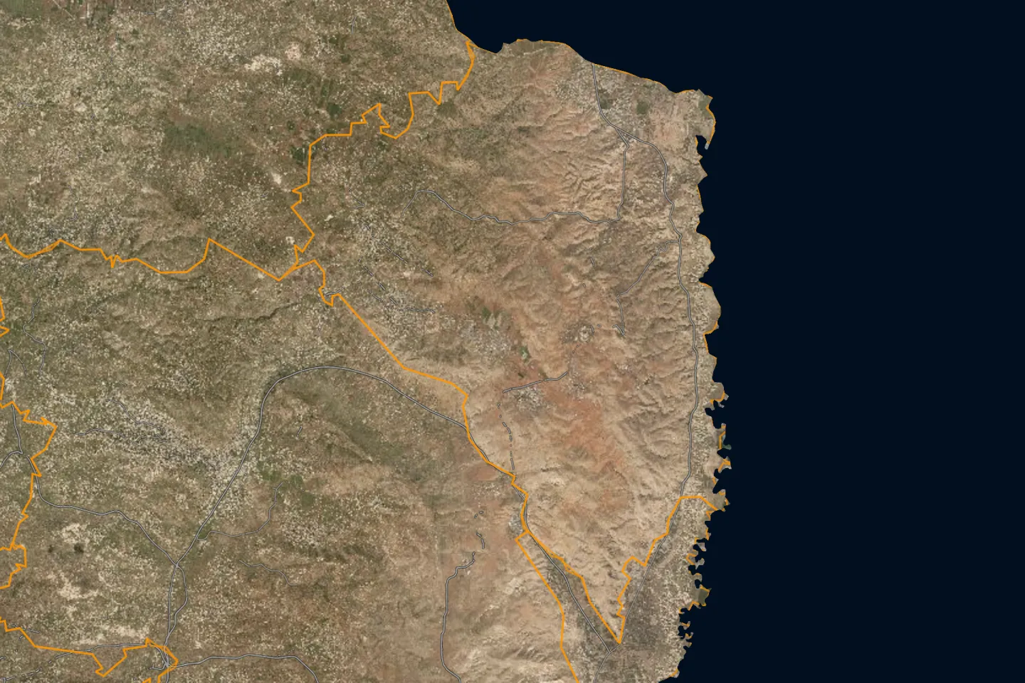
Towns and villages of Tubas Governorate
The 2017 census localities layer holds 22 localities in Tubas Governorate, listed here from the most populous. The population is what the layer states for each locality; the sum of these counts is not necessarily the official figure for the governorate.
| Locality | Population (2017 census) |
|---|---|
| Tubasطوباس | 21,431 |
| Tammunطمون | 13,117 |
| 'Aqqabaعقابا | 8,239 |
| El Far'a Campمخيم الفارعة | 5,625 |
| Wadi al Far'aوادي الفارعة | 3,998 |
| Tayasirتياسير | 2,878 |
| Bardalaبردلة | 1,607 |
| Ras al Far'aراس الفارعة | 1,250 |
| Locality | Population (2017 census) |
|---|---|
| 'Ein el Beidaعين البيضا | 1,138 |
| Al Malihالمالح | 354 |
| Khirbet 'Atufخربة عاطوف | 216 |
| Kardalaكردلة | 203 |
| Al Hadidiyaالحديدية | 183 |
| Al 'Aqabaالعقبة | 168 |
| Ibziqإبزيق | 129 |
| Al Farisiyaالفارسية | 118 |
The other 6 localities
| Locality | Population (2017 census) |
|---|---|
| Khirbet Tell el Himmaخربة تل الحمة | 77 |
| Khirbet ar Ras al Ahmarخربة الراس الأحمر | 74 |
| Kashdaكشدة | 66 |
| Locality | Population (2017 census) |
|---|---|
| Khirbet Yarzaخربة يرزة | 31 |
| Salhabسلحب | 25 |
| 'Ein El- Hiluaعين الحلوة | — |
Source: the 2017 census localities layer as published on the geospatial portal of the Ministry of Local Government, which the Qushan app shows as "Population density".
The population of the governorates is compared on the population page.
A dash means the layer gives no population for the locality. The list holds Palestinian localities only. Israeli settlements are not part of it; what concerns them is in the occupation section below.
Population and area of Tubas Governorate
Figures of the Palestinian Central Bureau of Statistics (PCBS) for Tubas Governorate:
Refugee camps in Tubas Governorate
The camps that PCBS lists under Tubas Governorate, with its mid-2017 population estimate. This is a mid-year estimate, not the census count, so it differs slightly from the figure in the table above.
| Camp | Population (mid-2017 estimate) |
|---|---|
| El Fara’a Camp | 5,576 |
Source: PCBS, 2017.
Land and settlement of title
Qushan's data for Tubas Governorate holds 15,765 land parcels in 358 blocks. Each parcel has its boundary on the map, its block number and parcel number, its area, its land settlement type, and its land use in the master plan where an approved plan exists.
Parcels by land settlement type
For each parcel the app states its land settlement type, that is, the state of settlement of title. The parcels in Tubas Governorate divide as follows:
| Settlement type | Parcels |
|---|---|
| Jordanian settlement of title, completed تسوية أردنية منتهية | 7,244 |
| Jordanian settlement of title, not completed تسوية أردنية غير منتهية | 4,894 |
| Palestinian settlement of title, completed تسوية فلسطينية منتهية | 2,468 |
The figures are what the app's data held on 13 November 2026; they are not official statistics. The data does not include all unsettled land, because the parcels of some blocks are not yet drawn in the source.
What these types mean, and their effect, is in the land settlement and tabu guide.
Share of parcels with completed settlement
Settlement of title is completed for 56.4% of the parcels of Tubas Governorate in the parcels layer; the layer counts 14,654 registered parcels covering 437 km².
Source: Qushan, from the Ministry of Local Government geospatial portal, snapshot 16 November 2026.
Completed and uncompleted settlement, by area
Source: Qushan, from the Ministry of Local Government geospatial portal, snapshot 16 November 2026. Survey year: not stated in the source.
| Status | Area | % |
|---|---|---|
| Settlement completed | 330 km² | 75.5 |
| Settlement not completed | 99.4 km² | 22.7 |
| Unspecified | 7.6 km² | 1.7 |
Registered and unregistered land
Source: Qushan, from the Ministry of Local Government geospatial portal, snapshot 16 November 2026. Survey year: not stated in the source.
Shares are of community land in the app's layer, not of the official area of the governorate.
| Status | Area | % |
|---|---|---|
| Registered | 413 km² | 98.4 |
| Not registered | 6.83 km² | 1.6 |
Localities with the most parcels
Locality names are given in Arabic, as they appear in the app.
| Locality | Parcels |
|---|---|
| طمون | 8,366 |
| طوباس | 6,612 |
| عقابا | 504 |
| تياسير | 255 |
Source: Qushan, from the Ministry of Local Government geospatial portal, snapshot 13 November 2026.
Master plans and land use
| Item | Value |
|---|---|
| Land inside an approved master plan | 20.2 km² |
| Plans deposited for public objection | 6.68 km² |
The source states no survey year for these figures.
Source: Qushan, from the Ministry of Local Government geospatial portal, snapshot 16 November 2026.
Largest land-use classes by area
Source: Qushan, from the Ministry of Local Government geospatial portal, snapshot 16 November 2026. Survey year: not stated in the source.
Class names are shown in Arabic, as the source publishes them.
| Class | Area |
|---|---|
| سكن أ | 5.96 km² |
| سكن ب | 5.76 km² |
| شارع مصدق | 2.58 km² |
| سكن ج | 2.16 km² |
| سكن أ باحكام خاصة | 1 km² |
| منطقة البلدة القديمة | 0.81 km² |
| مباني عامة | 0.45 km² |
| سكن زراعي | 0.33 km² |
| تجاري طولي | 0.2 km² |
| سكن ريفي | 0.15 km² |
The approved plans of Tubas Governorate use 31 classes; the table shows the ten largest.
What the classes mean, and the building rules, are in the master plans and residential classes guide.
Areas A, B and C
How the community land of Tubas Governorate divides among the Oslo classifications. Shares are of community land in the app's layer, not of the official area of the governorate.
Source: Qushan, from the Ministry of Local Government geospatial portal, snapshot 16 November 2026. Survey year: 1995.
| Classification | Area | % |
|---|---|---|
| Area A | 57.3 km² | 13.6 |
| Area B | 17.2 km² | 4.1 |
| Area C | 346 km² | 82.3 |
What each classification means is in the guide to Areas A, B and C.
Occupation and settlements
What the published layers state about Israeli settlements and military sites inside Tubas Governorate. Each figure carries its survey year and describes that year, not today.
| Item | Value | Survey year |
|---|---|---|
| Fenced area of Israeli settlements | 2.04 km² | 2016 |
| Military bases | 11 | not stated in the source |
| Road length under Israeli control | 33.9 km | 2014–2016 |
Source: Qushan, from the Ministry of Local Government geospatial portal, snapshot 16 November 2026.
Settler population
Source: Qushan, from the Ministry of Local Government geospatial portal, snapshot 16 November 2026. Survey year: 2014.
| Year | Settlers |
|---|---|
| 2012 | 1,666 |
| 2013 | 1,768 |
| 2014 | 1,845 |
Where the settlements, the wall and the checkpoints lie on the map is in the guide to settlements, the wall and checkpoints.
Roads and buildings
| Item | Value | Survey year |
|---|---|---|
| Classified road length | 121 km | 2014–2016 |
| Roads needing full rehabilitation | 32.5 km | 2014–2016 |
| Buildings | 6,948 | 1997–2016 |
| Building footprint | 1.14 km² | 1997–2016 |
| Mosques | 39 | not stated in the source |
| Documented place names | 895 | not stated in the source |
Source: Qushan, from the Ministry of Local Government geospatial portal, snapshot 16 November 2026.
Terrain
The lowest elevation in Tubas Governorate is 350 m below sea level and the highest 700 m above sea level, according to the contour lines in the source.
- Lowest elevation (below sea level)
- 350 m
- Highest elevation
- 700 m
Source: Qushan, from the Ministry of Local Government geospatial portal, snapshot 16 November 2026. Survey year: not stated in the source.
Neighbouring governorates
By the governorate outlines in the app, Tubas Governorate borders: Jenin, Nablus, Jericho & Al-Aghwar.
Pages of the other governorates: Tulkarm, Qalqilya, Salfit, Ramallah & Al-Bireh, Jerusalem, Bethlehem, Hebron, North Gaza, Gaza, Deir al-Balah, Khan Yunis, Rafah. The governorates are compared in the land statistics and on the land maps by governorate page.
External links
Reaching a parcel in Tubas
- Open the map and press the bar «بحث عن قطعة» (“search for a parcel”).
- Choose the governorate: طوباس, then the village, then the block.
- Enter the parcel number and press «بحث و تقريب» (“search and zoom”).
The full steps, and what to do when you do not know the number, are in the guide to finding a parcel by block and parcel number.
What you find for each parcel
- Record: locality, block, parcel number, area, land settlement type and Area classification.
- Zoning: land use in the master plan and the guidance building rules. Details are in the master plans and residential classes guide.
- Surroundings: length of road frontage, distance from the wall and from the nearest Israeli settlement, and nearby services.
- Outputs: a survey plan in DXF, a PDF report and a 3D model.
Limits and sources
- Qushan is an independent app, not a government product. It shows published administrative and engineering data, and it is not a legal record of ownership.
- Parcel data does not include the owner's name, and the app shows no land for sale and no prices.
- The app's figures are computed from the published layers as they are, with their dates and coverage. They are not official statistics. Some layers are old: the survey year is given with each figure, and the value describes that year, not today.
- Parcels, blocks and settlement types: Qushan, from the Ministry of Local Government geospatial portal, snapshot 13 November 2026.
- Indicators, areas and lengths: Qushan, from the Ministry of Local Government geospatial portal, snapshot 16 November 2026.
- Locality boundaries and their population counts: the 2017 census localities layer as published on the geospatial portal of the Ministry of Local Government.
- PCBS, Population, Housing and Establishments Census 2017: Final Results Summary (updated July 2018), Table 2, p. 71 (2017).
- PCBS, Estimated Population in Palestine Mid-Year by Governorate, 1997-2026 (2026).
- PCBS, Area, Population and Population Density in Palestine by Governorate, 2021 (area from Ministry of Local Government, 2017) (2021).
- PCBS, Projected Mid-Year Population by Locality 2017-2026 (rows named Camp) (2017).
Qushan — the parcel data shown is administrative and geometric, and is not a legal record of ownership.