
Qushan: everything known about a land parcel in Palestine, in one map
Qushan is a map app for land parcels in Palestine. It shows parcels, blocks, approved master plans and aerial imagery in one map, issues a survey plan, a 3D model and a parcel report for any parcel, and works without an internet connection. This page says what the app does, what it shows for each parcel, and where its limits are.
The Qushan interface is in Arabic. Where this page names a button, layer or section, it gives the Arabic label as it appears on screen, with its meaning in English.
What Qushan does
Five functions cover the whole job: reaching the parcel, reading its data, driving to it, seeing its boundary on site, and measuring it.
- Search by block and parcel number, or by specifications. The block number, the parcel number and the locality take you straight to the parcel. Without the numbers, search by specifications finds the parcels that match your conditions within a governorate or chosen localities: area and shortest side, land use and residential class, Area A, B or C, land settlement status and type, the width and surface of the adjoining street, elevation, distance from the wall, nearby services, and whether the parcel is built on. See how to find a parcel by block and parcel number.
- The parcel card. One card gathers what used to take visits to more than one office, and states the source of each item and how far to trust it.
- Navigation to the parcel, offline. The app computes the route to the nearest access point of the parcel, gives turn-by-turn directions, and recalculates when you leave the route. It warns of the checkpoints and closures listed in the data of the UN Office for the Coordination of Humanitarian Affairs (OCHA) along the route, and of roads inside Israeli settlements. Guidance also shows on CarPlay. Checkpoint status changes daily, and the app does not know the state of the road at the moment you pass.
- Augmented reality. Standing on site, the camera shows the parcel boundary drawn on the ground and tells you whether you are inside it. The view relies on GPS and the compass, with an estimated accuracy of 3 to 10 metres, and is not meant for surveying or for legally fixing a boundary.
- Measuring, historical imagery and saved parcels. Distance and area on the map, with points snapping to parcel corners and boundaries; aerial imagery of earlier years, exported as video or images that show how a site changed; saved parcels, shared by a link that opens them in the app; and figures for governorates and localities.

What a parcel card shows
Tap any parcel and its card opens, with five sections:
- Record: governorate, locality, block (حوض, hawd), neighbourhood, parcel number, area, land settlement type, Area classification and coordinates.
- Zoning: land use, setbacks, number of storeys, maximum built area, and the net area after deducting approved roads. See the zoning and master plan guide.
- Surroundings: length of road frontage, nearest planned road, distance from the wall and from Israeli settlements, and nearby services. See settlements, wall and checkpoints.
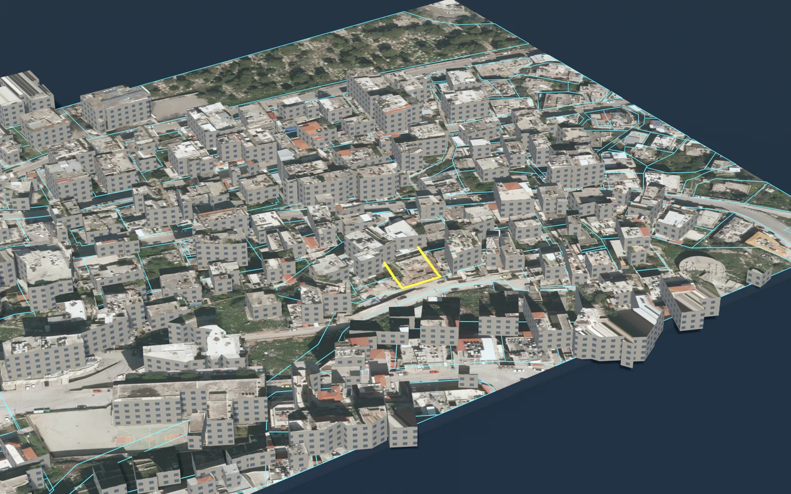
- 3D model: the terrain of the parcel and its buildings in three dimensions, in three display styles, with a fly-around video.
- Settlement: the land settlement documents published by the Land Authority for the locality. See the land settlement and tabu guide.

Thematic maps of the land and its surroundings
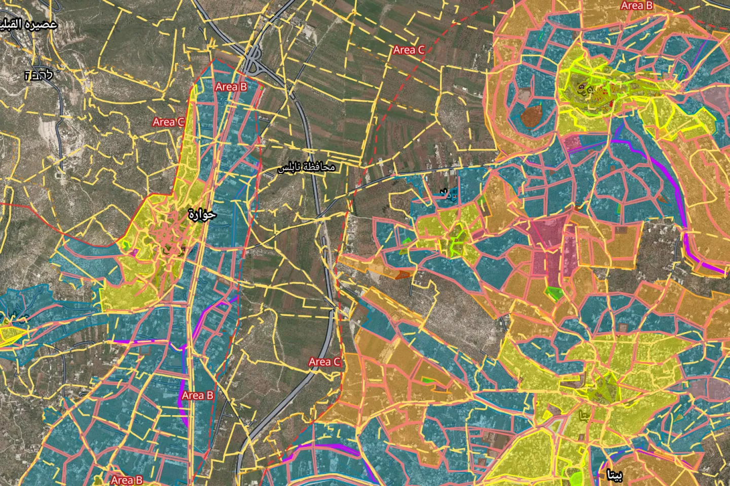
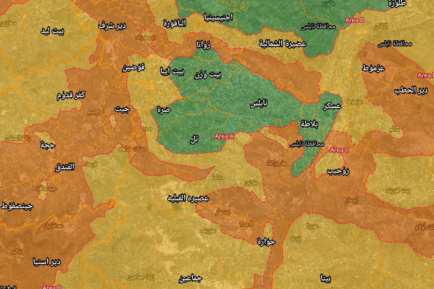
Besides parcel boundaries and data, the app shows thematic layers that describe the land itself and what lies around it. Each has a colour key on the map. The images below are unedited captures from the app.
- Population density: people per square kilometre in each locality. Source: Palestinian Central Bureau of Statistics, 2017 census.
- Land use: what the approved master plan allows in each zone: residential classes, commerce, public facilities and roads.
- Rainfall: the annual average, in millimetres.
- Soil types: the prevailing soil of an area.
- Groundwater protection: how well the ground resists pollution reaching the groundwater.
- Land cover: what actually covers the ground: built-up land, olives, crops, forest and pasture.
- Geology: the geological age of the rock at the surface.
- Oslo classification: Areas A, B and C in colour, which decide the authority that issues a building licence. See the Areas A, B and C guide.
Source of the last seven layers: the Ministry of Local Government (GeoMOLG). The full list of layers and sources is in map layers.
Outputs you can hand over as they are
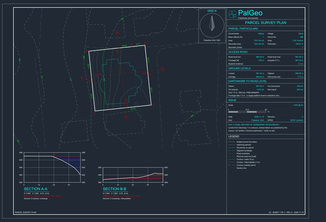
The work does not end when the parcel is found. The app issues files that an engineer, a lawyer and a buyer can rely on. Everything shown here was produced by the app itself.
- Survey and site plan (DXF): the parcel boundary with side lengths and corner coordinates, contour lines, approved roads, two ground sections and a cut-and-fill calculation, on named layers that AutoCAD opens directly. See the survey plan guide.
- Parcel report (PDF): area, land settlement, Area classification and land use, number of storeys and maximum built area, and what to check before buying, in a document you can send. See what to check before buying land.
- 3D terrain model: three styles: standard, artistic and aerial image. Exported as a model or as a fly-around video of the parcel.
Platforms
One app with a native Arabic interface: on iPhone and iPad, on Android phones and tablets, and on the web. On a tablet the map sits beside side panels; on a phone one hand is enough. The web version is open now at map.qushan.ps; the App Store and Google Play versions are marked as coming soon.
Offline: one pack per governorate
Much land lies outside network coverage. Parcel data is therefore prepared in advance as one pack per governorate, downloaded once, and search and parcel identification work from it directly. The packs published now hold 939,014 parcels in 8,697 blocks from 16 governorates. The counts for each are in land maps by governorate.
The free account
A free account lets you try every feature within a monthly allowance, which renews at the start of each month, and keeps your usage and plan on one page. There is no password: you sign in with your email address and a six-digit code. See the plans section (in Arabic).
Limits of what the app offers
- Qushan is an independent app, not a government product. It shows published administrative and engineering data, and it is not a legal record of ownership.
- Parcel data does not include the owner's name, and the app shows no land for sale and no prices.
- Parcels, plans and contour lines come from the geospatial portal of the Ministry of Local Government. Streets and place names come from OpenStreetMap and its contributors. Checkpoints and closures come from the UN Office for the Coordination of Humanitarian Affairs.
- Phone GPS is accurate to metres, not centimetres. The app states its accuracy on screen and on its plans, and an authoritative survey remains the work of a licensed surveyor.
Guides in English
- Find a parcel by block and parcel number
- Land settlement and tabu
- Master plans and residential classes
- Areas A, B and C
- Settlements, wall and checkpoints
- Before buying land
- Survey plan in DXF
- Map layers and their sources
- Land statistics
- Land maps by governorate
Qushan — the parcel data shown is administrative and geometric, and is not a legal record of ownership.